Natural attractions
The Aerobic Corridor

The Aerobic Corridor is a long multipurpose trail of 58 km that connects the Municipality of Morin-Heights to the Municipality of Amherst through the municipalities of Huberdeau, Arundel, Montcalm, Lac-des-Seize-Îles and Wentworth North. The trail follows the right-of-way of the Canadian National railroad, abandoned since 1962.
Between Amherst and Montcalm, the trail is used as a bike path in the summer and as a snowmobile trail in the winter. Between Lac-des-Seize-Iles and Morin-Heights the Aerobic Corridor is a bike path in the summer and a cross-country ski trail in winter.
Parking
Two parking areas are offered in Arundel to access the Aerobic Corridor:
- 60, Morrison Road: Municipal garage and park ;
- 1, Rouge Road Parking (intersection of the Rouge and Village Road).
Agricultural landscape
Arundel is recognized for the quality of its agricultural landscape composed of alternating woodlots and panoramic visual fields, that offer singular breathtaking openings on the Rouge Valley.
Rouge River
The Rouge River forms the western boundary of the municipality that runs north to south. It is also one of the most important natural elements of the municipality.
The river is 161 km long, it starts at Fougère Lake in the north and flows south directly into the Outaouais River. Its last 10 kilometers are famous for rafting.
One of the main explanations for the name of the river is the color of its water that could be due to oxidation of iron in the Canadian Shield. However, its water is clearer than the water of the surrounding rivers. Another explanation would come from a red chalk deposit located in Nominingue lake that Algonquin and Iroquois used to paint “(Wikipedia).
Navigation tips
The Rouge River is a canoe path of high quality and accessible to both beginners and experts. It is important to learn about the difficulty of its trajectory before undertaking it, because the river has several falls and thresholds impassable by boat. Maps and books of the river are available from bookshops or via the internet. These tools allow you to target the best route that fit your needs and abilities.
The Rouge in Arundel
There is no direct public access to the Rouge River, however, to access it, you can take the public access to Beaven creek (beside the City hall). By using this 2.3 km long course in calm water, you can reach the Rouge River, just down the rapids under the bridge connecting Arundel to Huberdeau.
There is a local company that rents canoes and kayaks, located at 31, Morrison Road. (see «Canoe kayak Arundel» in the Business Directory).
Beaven Lake
Beaven Lake is the largest body of water in the municipality. This is a resort area popular with vacationers and retirees.
There is no public access to Beaven Lake. On the other hand, you can launch your canoe or kayak at Beaven Creek Park behind City Hall at 2, Village Street. A public dock is installed in summer and the park pavilion offers 2 bathrooms and a drinking water dispenser.
Code of ethics
To ensure harmony between the residents and users of the Rouge River, the municipality recommends paddlers to apply the code of ethics of the Quebec Federation of canoeing and kayaking.
Boat washing
In order to avoid the introduction invasive algae into our waters, such as Eurasian milfoil, it is requested to wash the boat before each launching on any municipal lakes.
Arundel history
The municipality of Arundel was created by proclamation on July 8, 1856. It is bounded to the north by the town of Mont-Tremblant, on the east by the municipalities of Montcalm and Barkmere, on the south by the Municipality of Harrington and the west by the municipality of Huberdeau. The total area of the territory is approximately 16,566 acres.
Until 1857, no pioneer had moved to Arundel in order to establish there family. Only hunters, trappers and lumberjacks passed along the Rouge River, crossing Arundel.
Stephen Jake Beaven was the first white man to come to this Canton and live there from hunting, trapping and trading. The indigenous natives (Weskarini Algonquin First Nation) accepted him as one of them and traded with him. In 1822 he built a hut that served as a trading post where Beaven Creek empties into the Red River.
One of the first institutions in Arundel was named by Sydney Bellingham, who had received a large part of the township as a concession from the provincial government for its efforts in the execution of surveying the township. He named the Arundel Township in honor of the heritage site, Arundel in Sussex England.
Arundel main streets
The first path, known as “Iroquois Road” (“Chemin des Iroquois”) was opened in 1879 and connected Arundel to Huberdeau. Deer Haven road, joined Arundel to Montcalm, and finally, the path from Arundel to Saint-Jovite (now Mont-Tremblant) stood largely on today’s #327 road.
Arundel railway
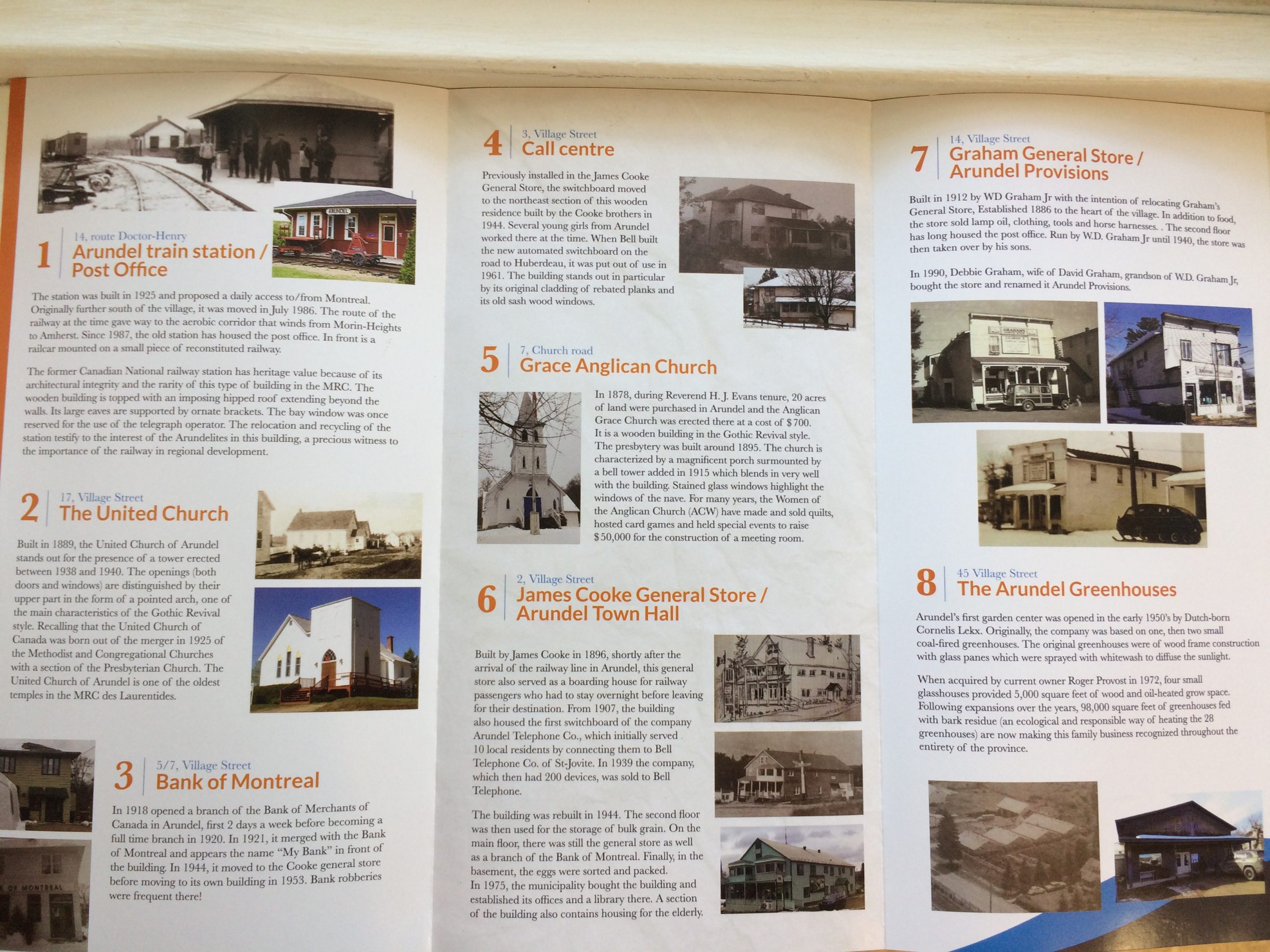
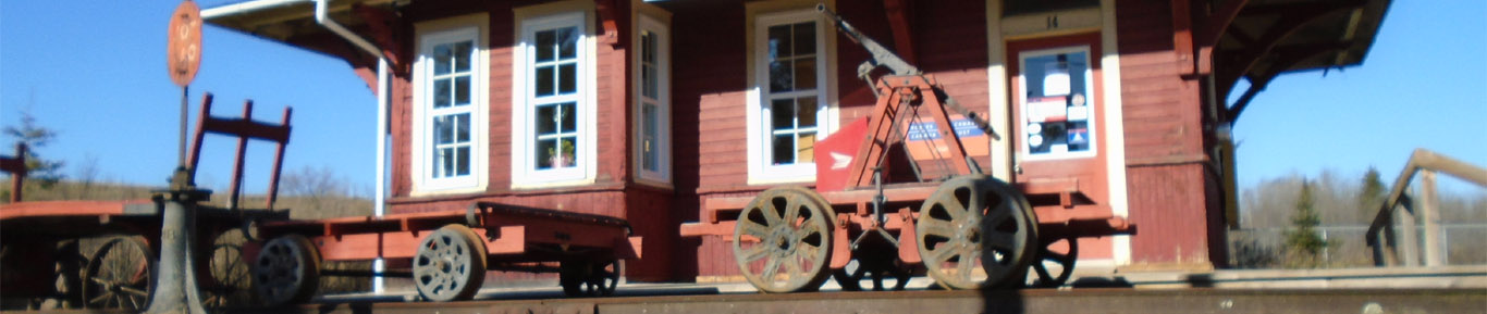
The railway came to Arundel in 1896. The first hangar was built in 1903 by CJ Staniforth. Subsequently, the Canadian National (CN) built its own railway station in 1912. That building still exist today, as the Arundel Post Office. The railroad line was abandoned in 1962 and the rails were removed.
Arundel economy
Arundel was predominantly an agricultural community with herds dairy cows, mainly Ayrshire and Holstein, sheep, pigs and hens. After World War II, the majority of the younger generation left Arundel for various reasons, specifically lack of work.
Now the pre-war generation has aged and the farms declined. Today, there are about 15-20 descendants of pioneers who still live in Arundel. There is only one dairy farm left and some cattle and sheep farms.
Presently, Arundel is mainly a community of retirees, a “dormitory” community of workers in other regions, and of cottage owners.
Arundel history books
A detailed history of Arundel is found in the book “The History of Arundel“, compiled in 1954 by the Women’s Institute of Arundel, and in “The 150th anniversary of the historic families of Arundel ” compiled in 2007. Both books are available for reference at the Arundel library.
Some editions on the history of Arundel
- The Tweedsmuir Village Histories
Heritage:
The Anglo-Saxon architectural heritage
The village center of Arundel has many heritage buildings. Several residential buildings built before 1955, in the American vernacular architectural style, give the village center a unique look in the Laurentians. The Anglo-Saxon origin of most of the population of Arundel may explain the importance of the architecture of American origin and the presence of distinctive architectural features. Unfortunately, some of these historic buildings suffer from a loss of architectural authenticity and substantial physical deterioration.
A heritage inventory was conducted by the MRC des Laurentides in 2013 on the territory of the MRC. This report identifies thirty-two (32) Arundel buildings that warrant to be conserved and enhanced. To view the report or to view the property sheets, click one of the following links:
Heritage Trail
A heritage trail has been set up, starting at the village post office (former railway station) at 14, route Dr Henry.